
Transforming Field Recon Planning with Intelligent Hydro Data, Spatial Analytics, and Predictive Validation
Most utilities already generate massive volumes of it across GIS layers, SCADA streams, sensor telemetry, drone inspections, maintenance logs, work orders, and asset intelligence systems.
In many hydro utility environments, field teams still spend significant operational time locating assets, reconciling GIS inconsistencies, coordinating inspection routes, and validating disconnected infrastructure records. That operational lag directly impacts inspection productivity, maintenance responsiveness, asset accuracy, and long-term infrastructure planning.
Now compare that to utilities adopting AI-powered planning for hydro network field validation. By combining geospatial intelligence, predictive analytics, historical inspection data, sensor-driven insights, and AI-enabled route optimization, utilities are improving field execution efficiency, strengthening infrastructure visibility, and reducing unnecessary validation cycles.
Industry research across utilities and infrastructure operations continues to show that AI operational planning can significantly improve field productivity, accelerate infrastructure response times, and enhance decision-making accuracy across distributed asset networks.
In this blog, we explore how AI-powered planning is transforming hydro network field validation beyond workflow automation, shifting field recon planning to intelligent, risk-aware operations that enable smarter inspections, optimized field deployment, and more resilient hydro infrastructure management at scale.
What is AI-Powered Hydro Network Field Validation?
AI-powered hydro network field validation is the use of artificial intelligence, geospatial analytics, machine learning, and predictive planning to optimize how hydro infrastructure inspections and field verification activities are planned and executed.
Instead of relying on static GIS maps, manual scheduling, and reactive inspection workflows, AI systems continuously analyze operational datasets such as GIS records, sensor data, inspection history, asset performance, and spatial risk indicators to improve field planning decisions.
AI-powered validation helps utilities identify
- Which assets require immediate validation
- Which network zones carry higher operational risk
- Which inspection routes improve field productivity
- Which infrastructure anomalies need rapid verification
- Which validation sequences reduce travel inefficiencies
- Which historical failure patterns indicate hidden infrastructure risks
Core Technologies Powering AI-Based Hydro Field Recon Planning
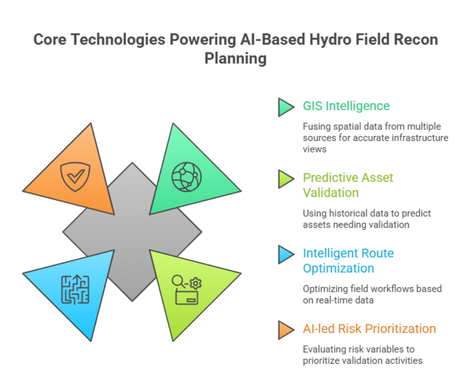
GIS Intelligence and Spatial Data Fusion
Geospatial intelligence forms the foundation of AI-powered hydro field validation. Modern hydro utilities generate infrastructure data from multiple operational systems, including GIS repositories, SCADA platforms, LiDAR mapping, drone inspections, satellite imagery, mobile survey applications, and asset management environments.
Organizations such as Esri, Autodesk, and Bentley Systems continue to expand spatial intelligence and digital twin technologies that help utilities improve infrastructure visualization, topology mapping, and real-time network visibility.
AI models consolidate these fragmented datasets into unified spatial intelligence layers that provide a more connected and accurate view of hydro infrastructure networks.
This enables utilities to identify
- Missing or outdated asset records
- Spatial inconsistencies across network layers
- Pipeline connectivity gaps
- Network topology anomalies
- High-risk infrastructure clusters
Predictive Asset Validation
AI-powered validation systems use historical inspection data, maintenance history, environmental conditions, pressure behavior, and asset performance trends to predict which infrastructure assets are most likely to require field validation.
For example, AI can prioritize
- Pipelines in high-corrosion environments
- Reservoir assets with recurring maintenance patterns
- Underground infrastructure near excavation zones
- Aging valve systems with incomplete GIS history
This improves field efficiency while enabling more proactive hydro asset management.
Intelligent Route Optimization
Route coordination remains a major operational factor in hydro field execution efficiency. AI planning systems optimize field workflows by analyzing geographic distribution, inspection priority, crew availability, and operational constraints in real time.
AI enables utilities to improve
- Crew movement and deployment
- Inspection sequencing
- Traffic-aware dispatch planning
- Geographic clustering of validation tasks
- Resource allocation efficiency
- Multi-site inspection scheduling
This allows field teams to validate more assets in less time while reducing fuel consumption, travel inefficiencies, and operational overhead across large hydro service areas.
Technology providers such as Oracle, IBM, and SAP are increasingly integrating AI operational planning, asset intelligence, and predictive logistics capabilities into enterprise infrastructure management platforms.
AI-led Risk Prioritization
AI-powered planning platforms continuously evaluate infrastructure risk variables to help utilities prioritize high-impact validation activities.
These systems assess factors such as
- Asset age and lifecycle condition
- Historical failure frequency
- Environmental exposure risks
- Hydraulic pressure behavior
- Maintenance backlog trends
- Inspection history and asset criticality
- Population and service impact zones
By prioritizing field validation based on operational risk, utilities can allocate resources more effectively, improve infrastructure resilience, and strengthen long-term hydro network reliability.
How AI Improves Hydro Field Recon Planning Workflows
Automated Validation Preparation
AI-powered planning systems streamline pre-inspection workflows by automatically generating validation-ready operational packets before field crews are dispatched.
These AI-generated validation packages can include
- GIS overlays and spatial references
- Asset history and maintenance records
- Inspection priorities and validation checkpoints
- Infrastructure risk indicators
- Optimized route sequences
- Satellite and aerial imagery references
- Nearby asset and network dependencies
Dynamic Scheduling and Dispatch
Hydro infrastructure environments are highly dynamic, where operational conditions can shift rapidly due to pressure fluctuations, leak indicators, weather events, emergency maintenance requirements, or network disruptions.
AI-powered scheduling systems continuously analyze operational data and automatically adjust field validation plans based on
- Real-time infrastructure conditions
- Crew availability and proximity
- Infrastructure criticality
- Incident escalation levels
- Sensor-driven alerts and anomalies
This adaptive planning approach enables utilities to improve field responsiveness, optimize resource deployment, and prioritize validation activities more efficiently across distributed hydro networks.
Real-Time Data Synchronization
AI-enabled mobile inspection platforms synchronize field observations directly into centralized GIS, asset management, and operational intelligence systems in near real time.
Utility modernization platforms from companies like Schneider Electric, Siemens, and GE Vernova are increasingly focused on enabling connected infrastructure operations, intelligent asset visibility, and real-time field-to-control-center data synchronization.
This enables utilities to achieve:
- Faster infrastructure visibility
- Reduced manual data duplication
- Improved hydro asset traceability
- More accurate and continuously updated network records
| Hydro Field Validation Area | Traditional Planning Approach | AI-Powered Recon Planning Approach | Operational Impact |
| Asset Validation | Manual asset verification using static GIS records | AI validation using real-time spatial intelligence | Faster and more accurate infrastructure validation |
| Inspection Planning | Reactive scheduling and manual coordination | Predictive inspection prioritization based on operational risk | Improved field productivity and planning efficiency |
| Route Optimization | Fixed or manually assigned field routes | AI-optimized routing using geographic clustering and live conditions | Reduced travel time and operational costs |
| GIS and Network Visibility | Fragmented infrastructure visibility across systems | Unified geospatial intelligence and data fusion | Stronger hydro network visibility and traceability |
| Infrastructure Risk Identification | Periodic or experience-based assessments | Continuous AI-driven risk analysis and anomaly detection | Faster identification of high-risk infrastructure zones |
| Field Data Collection | Delayed manual updates from field teams | Real-time synchronization through AI-enabled mobile platforms | More accurate and continuously updated asset records |
| Resource Allocation | Static crew assignment models | Dynamic resource deployment based on operational priorities | Better workforce utilization and response efficiency |
Operational Benefits of AI-Powered Hydro Network Validation
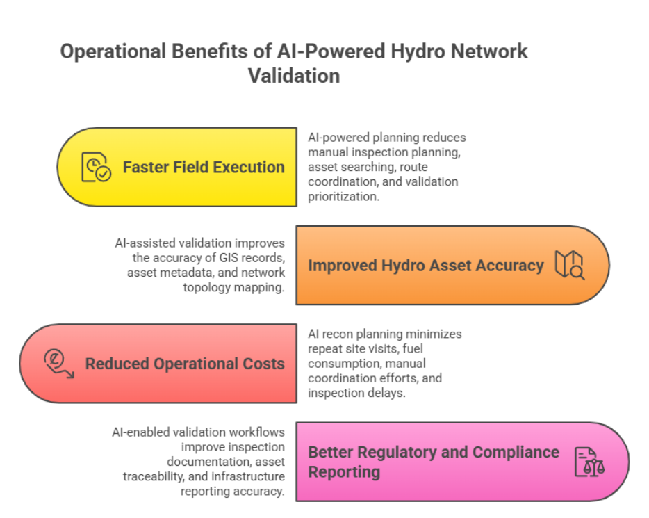
Faster Field Execution
AI-powered planning improves field execution by reducing the time spent on manual inspection planning, asset searching, route coordination, and validation prioritization. With intelligent scheduling and optimized workflows, field teams can focus more on infrastructure validation and less on operational inefficiencies.
Improved Hydro Asset Accuracy
AI-assisted validation helps utilities improve the accuracy of GIS records, asset metadata, and network topology mapping. By validating underground infrastructure connectivity and identifying data inconsistencies, utilities can build more reliable hydro network intelligence for long-term infrastructure planning.
Reduced Operational Costs
AI recon planning minimizes repeat site visits, fuel consumption, manual coordination efforts, and inspection delays. Optimized field deployment and resource allocation help utilities improve operational efficiency while reducing overall operational expenditure.
Better Regulatory and Compliance Reporting
AI-enabled validation workflows improve inspection documentation, asset traceability, and infrastructure reporting accuracy. This strengthens audit readiness, supports regulatory compliance, and enables more consistent operational governance across hydro utility networks.
Challenges Utilities Must Address Before AI Adoption
Data Quality and Infrastructure Readiness
AI-powered hydro validation depends heavily on accurate and structured data environments. Utilities must first address inconsistent GIS records, duplicate asset entries, missing metadata, poor topology alignment, and fragmented legacy systems.
Without reliable hydro data foundations, AI models cannot deliver accurate operational insights or validation recommendations.
Workforce Enablement and Operational Adoption
Successful AI adoption requires utilities to equip field teams with the skills needed to work alongside intelligent planning systems.
Teams must be trained to interpret AI recommendations, use mobile validation tools, understand spatial intelligence outputs, and collaborate within centralized operational planning environments. Human expertise continues to play a critical role in hydro infrastructure validation.
System Integration and Interoperability
Many hydro utility environments operate across disconnected operational platforms. Scaling AI-powered field validation requires seamless integration between GIS systems, SCADA platforms, asset management solutions, inspection software, mobile field applications, and analytics environments.
Interoperability across these systems, AI initiatives often remain limited in operational impact and scalability.
Best Practices for Implementing AI-Powered Hydro Recon Planning
Start with High-Impact Validation Zones
Utilities should begin AI adoption with high-priority infrastructure areas rather than attempting large-scale transformation immediately.
Focusing on high-risk pipeline corridors, critical reservoir infrastructure, frequent maintenance zones, and areas with low GIS confidence helps utilities achieve faster operational outcomes and measurable field efficiency improvements early in the implementation cycle.
Build a Unified Hydro Data Foundation
AI-powered planning performs best when hydro data environments are standardized and connected.
Utilities should prioritize GIS standardization, spatial data cleansing, asset metadata structuring, topology validation, and cross-system synchronization to improve infrastructure visibility and operational intelligence accuracy across hydro networks.
Combine AI with Human Operational Expertise
Field engineers, planners, and infrastructure specialists provide the operational context needed to validate AI recommendations and improve field execution accuracy. AI enhances operational intelligence, but domain expertise remains essential for resilient hydro infrastructure management.
Final Thoughts
AI-powered planning is redefining how hydro utilities approach field validation and infrastructure recon planning.
By combining spatial intelligence, predictive analytics, GIS integration, risk prioritization, and real-time operational data, utilities can transform field operations into proactive intelligence-driven systems.
The outcome is more adaptive field recon planning, stronger infrastructure visibility, and faster operational decision-making across distributed hydro networks.
AI enables utilities to build more accurate hydro network models, improve infrastructure reliability, reduce operational inefficiencies, and strengthen long-term asset management strategies.
As the hydro industry continues to modernize, AI-powered field validation will become a critical capability for utilities seeking operational resilience, smarter infrastructure planning, and sustainable network management at scale.
Frequently Asked Questions (FAQs)
1. What is AI-powered hydro network field validation?
AI-powered hydro network field validation is the use of artificial intelligence, geospatial analytics, and predictive operational intelligence to optimize hydro infrastructure inspections, asset verification, and field recon planning. It helps utilities improve inspection accuracy, infrastructure visibility, and operational efficiency across hydro networks.
2. How does AI improve hydro field recon planning?
AI improves hydro field recon planning by analyzing GIS data, sensor inputs, inspection history, and operational conditions to optimize inspection routes, prioritize high-risk assets, automate scheduling, and reduce field inefficiencies. This enables utilities to execute faster and more intelligent validation workflows.
3. Why is GIS important in hydro network validation?
GIS plays a critical role in hydro network validation by providing spatial visibility into pipelines, reservoirs, valves, hydrants, and distribution infrastructure. AI-powered GIS intelligence helps utilities identify network inconsistencies, topology gaps, missing asset records, and infrastructure risk zones more accurately.
4. What are the benefits of AI-powered validation for hydro utilities?
AI-powered hydro validation helps utilities improve field productivity, reduce operational costs, strengthen asset traceability, improve infrastructure data accuracy, optimize resource allocation, and enhance regulatory reporting. It also supports more proactive and resilient hydro asset management strategies.
5. What challenges do utilities face when implementing AI in hydro operations?
Common challenges include inconsistent GIS records, fragmented legacy systems, missing asset metadata, disconnected operational platforms, and workforce adoption barriers. Successful AI implementation requires strong data readiness, system integration, and operational training frameworks.
6. How does predictive analytics support hydro infrastructure management?
Predictive analytics helps hydro utilities identify high-risk infrastructure assets, forecast maintenance requirements, detect potential network failures, and prioritize field validation activities based on operational risk. This enables more proactive infrastructure planning and improved hydro network reliability.